


Geological Wonders of The Great Wilderness
These awe-inspiring landscapes are more than fascinating natural wonders. They hold wisdom that helps us find our place in the world.
If it’s epic you’re after, you want The Great Trail. At 24,000 km (15,000 mi), this trek spanning all of Canada is the longest multi-use recreational trail network in the world. British Columbia’s 1,700-km (1,050-mi) scenic portion hits forest, mountains, and coastline from Victoria on Vancouver Island to the Rockies, and you can choose your mode: on horseback, bike, in a canoe, or on foot—or in winter, on cross-country skis or by snowmobile.

The Great Trail links 15,000 communities along 24,000 km (15,000 mi).
A community-driven project 25 years in the making, the trail is set for completion in 2017 in honour of Canada’s 150th birthday. Celebrate by striking out on one of these top routes in BC’s eight regions. Find province-wide options at Trails BC, or plan a biking trip on the Cycling BC site. Download the app, grab your pack, and hit the trail.

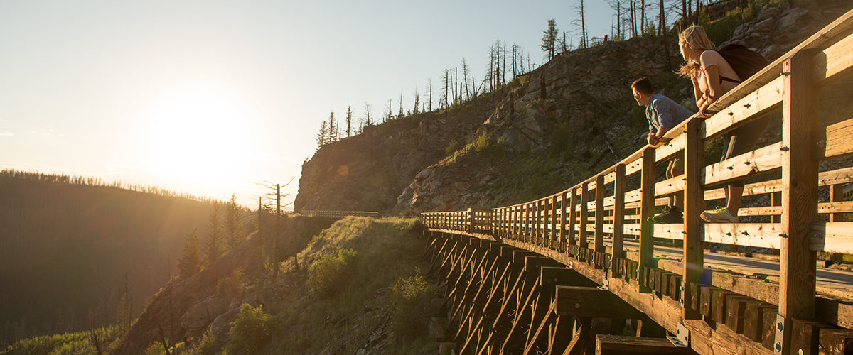
Myra Canyon Kettle Valley trestles in Kelowna. Photo: TourismKelowna.com/Wayne Dudych
Much of The Great Trail follows reclaimed railroad routes. Such is the case with the Kettle Valley Rail Trail, the historic, 400-km (249-mi) 1915 Brookemere-Midway line once used to move silver ore from mountains to coast. It is also arguably the province’s most spectacular piece of the trail, with views over the Okanagan Valley vineyards and Okanagan Lake. Even non-railroad buffs can’t help but marvel at the advanced engineering behind the trestles and tunnels created to bring trains through steep peaks and over deep river gorges. The most thrilling section is Kelowna-Myra Canyon, a national historic site with 12 km (7.5 mi) of hair-raising canyon views from 18 ravine-spanning trestles. The fact that there are award-winning wineries and u-pick peach farms within cycling distance only sweetens the deal.

The Kettle Valley Rail Trail follows the abandoned rail corridor of the Kettle Valley Railway.

A biker coming off of the Selkirk trestle on the Galloping Goose trail. Photo: Tourism Victoria
BC’s green capital city Victoria, famed for its gardens, is an ideal place to start a cycling adventure. There are two options: The popular 55-km (34-mi) Galloping Goose Regional Trail makes a well-rounded weekend bike tour. Covering urban, rural, and wilderness, it traces an old WWI freight railway line from downtown Victoria to a mining ghost town via seaside outdoor adventure hub Sooke, home to orcas and bald eagles, and the Saanich Peninsula, a favourite food and wine destination. Spend the night in Sooke, and explore East Sooke Regional Park on day two before returning.

The Galloping Goose Regional Trail, named after a noisy passenger rail-car from the 1920s.
The 30-km (19-mi) Shawnigan out-and-back day trip goes from waterfront resort Shawnigan Lake to the 1911 Kinsol Trestle. The impressive 190-m (614-ft) structure spanning the Koksilah River 45 m (145 ft) up is one of the tallest freestanding timber trestles in the world. Swim, sail, or canoe on the lake pre- or post-cycle.

Shawnigan Lake to the 1911 Kinsol Trestle.
Even if you don’t take the trail all the way to the Arctic Ocean, the Alaska Highway portion in BC’s northeast is ideal for adventurers. While you’re likely to come across mountain goats, bears, and moose in the wilderness, you’ll for sure encounter sweeping glacier-carved lake and river valley scenery, but without the crowds. This section of the trail begins in the Yukon just outside BC, then runs 1,000 km (621 mi) along the Alaska Highway and back roads through forest and into the northern Rockies, ending at Dawson Creek. A highlight is a dip in Liard River Hot Springs. Many make it a road trip, but the well prepared can cycle or hike it.

2017 marks the 75th anniversary of the Alaska Highway.

Beautiful Kootenay Lake from above. Photo: Kootenay Rockies Tourism/David Gluns
Rugged mountain landscapes are what you’ll find in the Purcell Mountains, the most challenging but scenic part of The Great Trail in BC. The full 400-km (250-mi) portion crosses two 2,000-m (6,500-ft) high mountain passes, and pretty Oliver Lake, just before the summit, is a highlight. Closed in winter, Gray Creek Pass is for the hardcore. Beginning at Gray Creek Store near eastern Kootenay Lake, the 80 km (50 mi) on mostly forestry roads to Kimberley is tough, with steep ups and downs, no cell service, and few amenities. Cyclists must bring their own gear and repair tools. Those hardy hikers and fat tire riders who take on Gray Creek Pass are rewarded with a pristine wilderness of clear alpine lakes, snow-capped glaciers, and wild flower-carpeted meadows.

Gray Creel Pass/East Kootenay and Rockies.
Featured image: A couple enjoys the sunset on one of the trestle bridges overlooking Myra Canyon on the Kettle Valley Railway. Photo: Kari Media