Maps
Hiking up the river banks of the Fraser River in Lillooet

Rainforest to Rockies: To Gold Country and Back

4-6 days, 828 km (514.5 mi)

Unearth the local treasures of Gold Country on a unique circle route made for culture buffs and outdoor adventurers alike.

Share  Facebook Twitter pinterest logoPinterest

Rainforest to Rockies logo

Go deeper into BC’s history along roads less travelled on this Rainforest to Rockies journey. Immerse yourself in history, cultures, and communities and witness remarkable nature. Find local gems, discover the historical significance of the province’s Gold Rush era, and learn about the Indigenous Peoples who have lived and flourished in these regions for millennia. 

Part 1

Vancouver to Lillooet

Lions gate Bridge | | Kezia Nathe

Travel from city to country in almost no time at all. Set off from Vancouver, a scenic and culturally vibrant city on the edge of the Pacific Ocean. The paved Seawall path loops around Stanley Park with views of the Lions Gate Bridge. This picturesque bridge crosses Burrard Inlet, a shallow fjord and busy port area, towards the mountains on Vancouver’s North Shore. From here, travel north along the Sea-to-Sky Highway 99 and witness the awe-inspiring ocean and mountain panoramas of Howe Sound—a UNESCO-designated biosphere—and its small islands.

If you’re keen on nature-based pursuits, the recreation hubs of Squamish and Whistler lead to the Pemberton Valley’s farmlands. Branching northeast past Lillooet Lake, Duffey Lake Road is notable not just for its scenery, lakes, and wildlife sightings (look for mountain goats on ridges or great blue herons on the lakes) but also for its Gold Rush history. Prospectors and supplies passed through the challenging Cayoosh Pass along this stretch. 

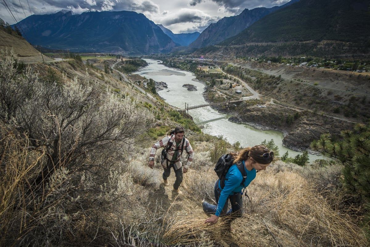
Coming into Lillooet, one of the province’s oldest towns, the legacy of the BC Gold Rush that began in 1858 becomes evident. Visit the Lillooet Museum and learn about the Fraser River Gold Rush and exploration in the area. See items including traditional baskets and beadwork crafted by artists from the St’át’imc Nation. History buffs can learn more on the Golden Miles of History walking tour, or travel farther up the Gold Rush Trail

Part 2

Lillooet to Ashcroft

Hat Creek Ranch, near Cache Creek | Blake Jorgenson

This historically important stretch is where an influx of California gold miners helped spark Great Britain’s decision to create the Colony of British Columbia in 1858. Moving south along Highway 12, admire sweeping cliffside views above the mighty Fraser River, the longest river in BC. The Fraser River’s gold-rich deposits, accessibility, and role as a transportation artery were pivotal during the province’s Gold Rush. 

Like much of the area, Lytton has a Gold Rush history, too. It also represents modern-day resilience for Indigenous communities and settlers as the land and its inhabitants continue healing from wildfires that devastated the town. Nearby, the Historic Hat Creek Ranch in Cache Creek features a traditional Shuswap kekuli pit house, stagecoach rides, and gold panning.

Part 3

Ashcroft to Princeton

Sundance Guest Ranch in Ashcroft | Cariboo Chilcotin Coast/Michael Bednar

Welcome to Ranch Country. South from Ashcroft on Highway 97C, follow the Thompson River and its deep canyons and valleys. Soon, the rolling hills, historic ranches, open ranges, and placid lakes of the Nicola Valley greet you en route to Merritt. Merritt is a horseback riding hotspot and is also known as Canada’s Country Music Capital.

Head south on ranchland-rich Highway 5A towards Princeton. Explore nearby red ochre cliffssacred to the Upper Similkameen Indian Bandthat overlook the Similkameen Spirit Trail, a National Historic Site. Snap photos of the town’s bronze sculptures, or head to the Swan Lake Sanctuary and wildlife refuge. 

Part 4

Princeton to Vancouver

China Ridge Trails, Princeton | Similkameen Valley/Darren Robinson

On your way back to Vancouver, you’ll find even more hiking and biking opportunities. Curving southwest along ultra-scenic Crowsnest Highway 3, enter E.C. Manning Provincial Park with its alpine meadows spreading out amid the impressive Cascade Mountains. Here, western anemones and yellow avalanche lilies splash colour into the landscape; you can also catch glimpses of bears, beavers, and moose near lakes.  

Continuing west, the grand sprawl of Fraser Valley fields framed by the Coast Mountains welcomes you back to Vancouver after your Gold Country adventurea trip to treasure.


Header image: Lillooet | Blake Jorgenson

Driving Directions

Part 1 - Vancouver
  • 6.25 km
  • 12 min
Show Map & Driving Directions

Start Planning

Need to Know

Find key travel information to help you plan your trip to BC.

Get Info
Plan Your Route

Check Drive BC for the latest information on road closures around the province.

Check Conditions
BC Parks

Learn about hiking and biking trails, provincial campgrounds, park closures, and more.

Explore