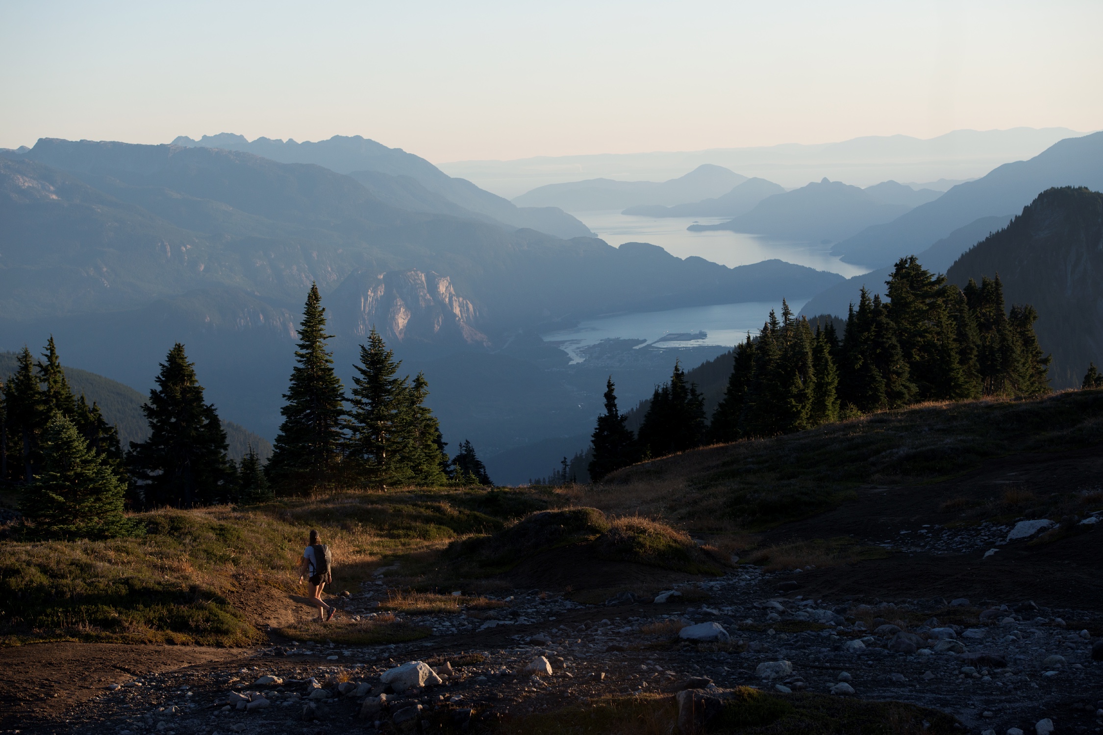
Vancouver, Coast & Mountains is British Columbia's most populated region, which helps explain why it has the province's most well-developed and easily-accessible array of hiking trails.
Hiking is the best – and sometimes the only – way to see some of this area's most unique features. Must-sees include the massive granite monolith of the Stawamus Chief; the turbulent tidal rapids at Skookumchuck Narrows; and one of BC's most-photographed mountain summits, Black Tusk, in Garibaldi Provincial Park.
Situated in the southwest corner of BC's mainland, the region's diverse geography includes secluded fiords, seaside bluffs, old-growth rainforests, and the alpine terrain of the Coast and Cascade mountain ranges.
Learn more about the Vancouver, Coast & Mountain Hiking Trails and Highlights:
Year-round Hiking Trails
The Vancouver, Coast & Mountains region is blessed by one of Canada's mildest climates. While Vancouver and the Sunshine Coast can be damp during autumn and winter, they won't be excessively cold or snowy.
Hiking season in the mountains above 1,100m/3,600ft usually spans from July through September, as routes are snow-covered or muddy during the rest of the year. Early August is a favourite time to hike the high elevation trails of Garibaldi Provincial Park and Manning Provincial Park, when their sub-alpine meadows become blanketed in a kaleidoscope of wildflowers.
Hiking Tours from Vancouver and Whistler
The cities of Vancouver and Whistler are two of the region's most convenient hiking hubs. Both are well-serviced by a variety of transportation options. For those seeking a guided experience, operators offer fully-catered hiking tours, including the option of helicopter-accessed alpine treks in Whistler.
Further afield, most of the region's notable hiking trails are situated in provincial parks, which are usually well-marked by highway signs. Having your own vehicle will open up the greatest variety of trail options and will allow you to be more flexible with your time. Local bookstores offer an array of books for the self-guided traveler. Trail maps are available from community Visitor Centres and many park entrances.
Hiking Safety Tips
The region's wilderness is rugged. Even trails at the edge of cities should be treated as serious backcountry. Proper planning, preparation, clothing and footwear appropriate to the conditions, and an adequate water and food supply are essential. Remember the following:
- Weather can change quickly, especially in the mountains. Dress in layers and bring wet-weather gear, no matter what season.
- Even the most popular, well-maintained trails can be rocky, tangled with roots, muddy and slippery.
- Wear hiking boots with good ankle and arch support and be prepared to get muddy. At higher elevations, snow and mud may linger on trails until late June or even early July. Prepare yourself accordingly.
- Please leave the area you visit undisturbed and be sure to carry out your garbage. Cougars, bears and other wildlife inhabit the region. Do not get too close to or attempt to feed wild animals.
Choose a Trail
Easy
Intermediate
Advanced
Hiking Trail Highlights
Alice Lake Provincial Park
A popular camping, fishing and swimming destination, Alice Lake Provincial Park (situated off Highway 99, approx. 10 minutes north of Squamish) offers numerous picturesque trails. The gently winding trail around the lake itself makes for a leisurely after-dinner stroll. Another popular route is Four Lakes Trail, a two to three hour circuit which takes walkers through canopied Douglas-fir and western red cedar forest past four charming woodland lakes.
- Rated: easy
- Approximate time required: varies by route
- Best time: March to October
- Alice Lake Park website
Garibaldi Provincial Park
Garibaldi Provincial Park offers over 90km/56mi of established hiking routes, making it a favourite destination for outdoor enthusiasts. The park's rich geological history, diverse vegetation, iridescent lakes and streams as well as abundant wildlife guarantees a memorable journey.
Musical Bumps to Singing Pass is famous for its panoramic views of surrounding glaciers and Cheakamus Lake. Begin at the top of the Whistler Mountain Gondola where the route extends past three summits. Complete the trip by either backtracking or following a trail that descends to Whistler Village. This 21-km/13mi trek takes seven to eight hours roundtrip.
A popular day hike is to glacier-fed Garibaldi Lake, an 18km/11mi roundtrip of approximately eight hours. Backpackers often camp for the night at the lake's wilderness campground before continuing to the summit of Black Tusk, a volcanic cone remnant. The hike to Black Tusk from Garibaldi Lake is a 14km/8.7mi, six-hour roundtrip.
The southwestern region of Garibaldi, also known as Diamond Head, is a blending of heather-covered meadows, serene lakes and mountain vistas. The 22km/14-mi roundtrip hike to Elfin Lakes requires about eight hours.
Garibaldi Park can be accessed by car from five entrances along Highway 99 between Squamish and Pemberton, starting just one hour north of Vancouver. The trailheads are anywhere from 4km/2.5 mi to 16km/10mi from Highway 99.
- Rated: difficult
- Approximate time required: varies by route
- Best time: July - October
- Wilderness camping: permitted
- Garibaldi Park website
Golden Ears Provincial Park
Plan for approximately a seven-hour hike up and five hours down on this 24km/15mi round trip in Golden Ears Provincial Park. This trail is recommended as an overnighter for all but the extremely fit. Extreme caution is advised and proper backcountry equipment is recommended. Hikers will delight in the views of Pitt Lake and the mountains. Be aware of the elevation change of 1,500m/4,921ft. Hikers must bring drinking water; expect snow into July near the end of the trail on Panorama Ridge.
- Rated: difficult
- Approximate time required: 12 hours
- Best time: July - October
- Wilderness camping: permitted
- Golden Ears Park website
Joffre Lakes Provincial Park
First, the easy climb: a short, pleasant stretch to the first of three aqua-blue lakes at Joffre Lakes, located off Highway 99, just over one hour north of Whistler. The steep, mountainous trek to Upper Joffre Lake can be challenging, but the reward is worth it: sweeping views, icefields and streams beneath the Matier Glacier. Hikers who tackle this in the summer months may catch some spectacular floral displays as well. Don't forget to bring a camera. Equip yourself well before attempting to conquer this 11km/6mi roundtrip through wilderness.
- Rated: intermediate
- Approximate time required: 6 hours
- Best time: July - October
- Wilderness camping is permitted
- Joffre Lakes Park website
Manning Provincial Park
Manning Provincial Park has 70,844ha/175,000ac of magnificent parkland welcoming hikers of all levels. It is located along Highway 3 between Hope and Princeton, three hours east of Vancouver. Hikers will appreciate the park's well-developed system of backcountry trails. Two of the more notable ones are the Sub-Alpine Meadows and the Lightning Lake Loop.
To reach the Sub-Alpine Meadows, take the winding road just opposite the now-closed Manning Park Resort. Routes from the meadows range in length from 20 minutes to several days. Hiking is at its best July to September.
Visitors in search of a stroll through gentle wilderness will value the Lightning Lake Loop, which skirts the shoreline of the first of four lakes in the Lightning Lake Chain. The 9km/5.6mi loop takes approximately two to three hours and is at its best May through October.
- Rated: easy to advanced
- Approximate time required: varies by route
- Best time: May to October
- Wilderness camping: permitted; fees apply
- Manning Park website
Skookumchuck Narrows Provincial Park
The word "Skookumchuck" is Chinook for "powerful waters." Skookumchuck Narrows Provincial Park is located off Highway 101 near Egmont, one hour north of Sechelt. Access the trail from the parking lot.
On a 3m/9.8ft tide, 909 billion litres/200 billion gallons of water pulse through the narrows connecting Sechelt Inlet to Jervis Inlet. There is a relatively flat walking trail from the site's parking lot to the viewing point at Roland Point. Time your jaunt through this coastal forest trail to arrive when the tidal surge is at its strongest.
Stawamus Chief
Dubbed "the Chief" by locals, this jagged beauty is a favourite weekend hike for many Vancouver residents. The Chief is located in Stawamus Chief Provincial Park, just five minutes south of Squamish via Highway 99. The trails are accessed from the day-use parking lot.
One of the largest free-standing monoliths in the world, the Chief rises 652m/2,140ft above Howe Sound – fit hikers are in for a rewarding workout. The steep roundtrip to the first summit is 6km/3.6mi. Rock climbers also gravitate to the Chief, unable to resist the magnetic pull of its granite face.
At the summit, hikers and climbers alike are in for a breathtaking vista of Howe Sound, the Squamish Valley and mountains as far as the eye can see.
Attributes
- Rated: advanced
- Approximate time required: 3-4 hours
- Best time: March - November
- Stawamus Chief Park website
Stein Valley Nlaka'pamux Heritage Park
Vast, 107,191ha/264,874ac Stein Valley Nlaka'pamux Heritage Park is the spiritual home of the Nlaka'pamux Nation and one of BC's premier areas for multi-day wilderness backpacking. Terrains, elevations and temperatures vary dramatically. Expect dry heat in the lower Stein Valley and snow (even in late summer) between Stein and Lizzie lakes, near the 2,954m/9,750ft summit of Skihist Mountain. Traversing the entire park takes at least eight days.
There is a variety of hiking trails to explore but accessibility varies depending on the snow pack. One of these, the Stein Trail, features a number of Aboriginal pictographs (rock paintings) and Asking Rock, where some Nlaka'pamux still stop to pray for safe passage through the valley. Please do not touch the pictographs. The Lizzie Lake to Stein Lake trail is located in a steep, high-elevation area at the western end of the park.
Stein Valley Nlaka'pamux Heritage Park is located in the Coast Mountains, between the Fraser and Lillooet River valleys. Its main trailhead is near the community of Lytton (a 10-minute drive away).
- Level of difficulty: intermediate to difficult
- Time required: single day – eight days
- Best time: April-October (lower trails); July-September (higher elevations)
- Wilderness camping: permitted
- Stein Valley Nlaka'pamux Heritage Park website
Sunshine Coast Trail
The Sunshine Coast Trail winds its way along the upper Sunshine Coast from Saltery Bay in the south to Sarah Point on the shores of Desolation Sound. The Sunshine Coast Trail is located on the upper Sunshine Coast near Powell River. No matter where you are on the trail you are never more than 6km/3.75mi from vehicle access.
Experienced and properly-equipped hikers can trek the length of the trail through towering, old-growth forest as well as by gentle lakes, crashing waterfalls and sublime seascapes. Day hikers can easily cover a much shorter block of ground.
- Rated: easy to difficult
- Approximate time required: varies by route; entire trail requires about 10 days
- Best time: April to October
- Wilderness camping: free sites found along the trail; off-trail lodging with transportation also available.
- Back to top
Read Less